20 |
Oilfield Technology
May 2015
Traditional search engines help, but lack precision. Often
what the geoscientist is looking for is not a verbal description,
but a physical location. Plugging a keyword into Google, or
other search tools, may unearth the desired information,
but will also include far too many inappropriate results
that require sorting. Even so, one cannot be sure the search
located all of the relevant data sources. Even if relevant data
is found, the geoscientist still needs to evaluate its accuracy
before beginning the process of transforming it into ready-
to-use formats, which can be incorporated into analytical
software tools such as ESRI’s ArcGIS, Schlumberger’s Petrel™
or other geospatial, modelling products.
Reversingthe80/20ratio
Given the effort required, internal corporate audits in some
of the larger oil and gas companies show that up to 80% of a
geoscientist’s time is likely spent searching for information
and formatting the data for entry, while only 20% is used
for the modelling and interpretation of results. That ratio
needs to be reversed. To make this possible required the
development of a new set of tools.
As a publisher of scientific information, including journals
and books covering Earth and Planetary Sciences, Elsevier
has the data the geoscientists need. But having the data was
not enough. In 2010, Elsevier launched a new tool called
Geofacets, specifically geared to ease the many inefficiencies
and painpoints around finding and integrating relevant and
valuable information from within journal articles, such as
isopach and gross depositional facies maps, seismic profiles,
TOC content in potential source rocks, etc. With Geofacets,
maps (and articles) are searchable via an interactive spatial
interface, which lets users zoom in to an area of interest, as
well as traditional text-based searches, both of which can be
refined by a unique set of attributes, including map type, scale
geologic basin, geologic age and more. When geoscientists find
a pertinent map, users can click to read the original abstract
and article so they can further evaluate the applicability
and reliability of the map. But of equal importance is that
geoscientists can download and import the maps and other
relevant information directly into a variety of tools such as GIS
software, presentation programs and, most recently, Petrel™.*
Geofacets features more than 400 000 maps, covering all
areas of the globe. And in 2015, Geofacets will increase its
content by an additional 20% with the addition of content
from Wiley Blackwell and the American Geophysical Union.
To make the maps easier to locate and to integrate with
other software, more than 275 000 maps are georeferenced
and downloadable as .geotiff files, which means that
geologists, geotechnicans, GIS-specialists can integrate the
content into their software – helping save time and money.
The maps are available in four formats: .geotiff and .xml
for integrating into ESRI’s ArcGIS and Petrel, .kmz files for
opening maps in Google Earth or other mapping software and
.jpg or .tif for importing into PowerPoint, Word or PDF.
Knowledge, insightand integrationfrom
explorationtoproduction
Geofacets can be used as a standalone tool, but its greatest
value comes when it is integrated with other tools. Every time
a geoscientist has to leave one platform to access data in
another, and then import and integrate that new map or other
information, it wastes time. To ease this process, 6 months
ago, Geofacets Connector for Petrel and Studio
*
was released.
The plugin is available on Schlumberger’s Ocean platform
and allows all the research and analysis to be done within the
software.
Typically, Petrel is used across the industry for seismic
interpretation, basin and reservoir modelling, reservoir and
field development, and production. The Geofacets Connector
supports traditional Petrel workflows, enabling users to
search and incorporate scientific literature within a Petrel
project, and also increases productivity by reducing the time
spent searching and formatting data in the early stages of
exploration. The following is a case study of how Geofacets
and the plugin provide knowledge, insight and integration all
in one platform.
Surenthar Thiakalingam, Petroleum Systems Analyst for
Schlumberger Information Systems, had a project to build a
3D-petroleum system model to identify potential prospects
within the Southwest African Coastal Basin (also known as
the Orange Basin). Specifically, the first task required the
identification of the existence of the four components of a
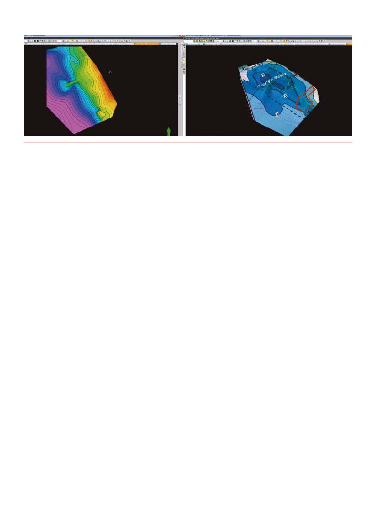
Figure 7.
Using themapping tool withinPetrel to digitise an isopachmapand 3D structuremap foundand loaded intoPetrel via theGeofacets Connector,
it is possible to identifywhere the seal is thickest, therefore, identifying low risk versus high risk areas.


