16 |
Oilfield Technology
June
2015
co-ordination with the Maritime Research and Fisheries representatives
on land avoided conflict and promoted a good working relationship
during operations.
Last year’s acquisition of part of the initial Horda survey was
conducted by the Oceanic Phoenix and the Viking Vanquish, each towing
twelve 8 km streamers, with 75 m separation. In order to acquire the data
as quickly as possible, the two vessels were employed simultaneously
on the survey, working semi‑independently but making use of advanced
navigation tools, that allow the planning and management of seismic
interference (SI) (or noise contamination from the nearby vessel shots)
to be only that which can be attenuated in processing. The success of
this strategy last year has led to it being used again for this season’s
acquisition in order to acquire as much data as possible before the
fishing season halts the surveys.
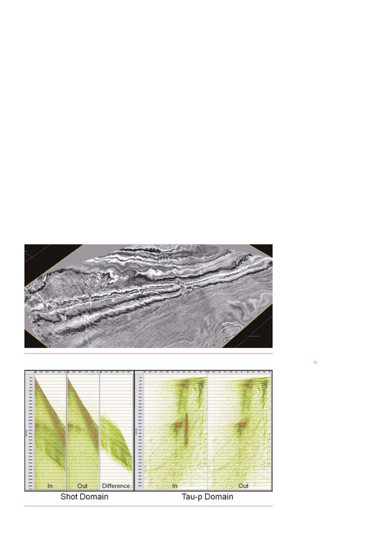
In the shot domain, SI tends to be coherent, dispersive and fairly
linear. When sorted away from shot order it tends to be incoherent,
randomand intermittent, as long as it does not occur at the same time
on each shot. The easiest way to ensure that SI is not synchronous is to
vary the vessel speed when the two vessels are passing each other so as
to avoid shot‑to‑shot coherence of noise. Where possible, SI is attenuated
by careful dip filtering in the shot domain, but, when necessary, data can
be sorted away from shot order so that the noise is randomised, and can
be attenuated withmulti‑dimensional impulsive denoise tools. In extreme
cases, the noise can bemodelled in the tau‑p domain and subtracted from
the input data. This combination of planned acquisition and processing
enables the vessels to work with up to 20 km separation and the data to
be acquired in half the time without degrading quality (Figure 5). As both
vessels use a conventional spread, there is no loss of near offsets (and
therefore shallow coverage) that would come fromusing an extra‑wide
streamer spread to reduce acquisition time.
Both the fast‑track and full imaging of the survey is being
undertaken in Norway. Fast‑track data of the first 8500 km
2
to be
acquired was delivered in September 2014, only 10 weeks after
completion of the acquisition. Both the final data for this area and the
fast‑track data for the full 18 000 km
2
Horda survey will be available in
October/November 2015. Gravity data over the area is being used to
define the basement depth, and this information is being incorporated
into the velocity model building for imaging the data. The full production
data is going through a comprehensive reservoir‑oriented processing
QC workflow to ensure the final delivered data will be reservoir‑ready
i.e. requires very minimal pre‑conditioning prior to elastic inversion and
reservoir characterisation studies. In this workflow, the data is migrated
at various key stages to look at the evolution of well‑ties, wavelet
stability and AVO compliance, etc. Information from several pre‑selected
wells is being integrated and maps of relevant QC products, following
horizons, will show spatial variations and conformity with known
geological information.
The Horda and Tampen surveys have been designed with longevity
inmind. The data are being acquired on a relatively dense grid (18.75m
crossline bins) and at an azimuth carefully selected to be correct for using
the survey as a baseline 4D in future. They cover several discoveries,
and although there are other 3D surveys in the area, none of these are
broadband or are as extensive. Horda
(and later, Tampen) will deliver an
unprecedented array of integrated
geoscience data in an easily accessible
form, that can be directly used by clients
for reservoir modelling, play evaluation,
well location, etc. Even clients who
wish to purchase only the seismic data
will benefit from the integration of well
and gravity data, as well as extensive
QC using AVO tools, to deliver a dataset
that is truly reservoir‑ready for them to
perform their own analyses. It is believed
that this survey represents the future of
multi‑client seismic surveys in Norway
– extensive, detailed, integrated and
cost‑effective.
Acknowledgement
The authors would like to thank
CGG Multi‑Client & New Ventures for
permission to publish this article. All
images are courtesy of CGG Multi‑Client
& New Ventures.
References
1.
Dowle,R., ‘Solidstreamernoisereduction
principles’,SEGExpandedAbstracts25,(2006),
pp.85‑89.
2.
Poole,G., ‘Pre‑migrationreceiverde‑ghosting
andre‑datumingforvariabledepthstreamer
data’,SEGTechnicalProgramExpanded
Abstracts2013,pp.4216‑4220.
3.
Siliqi,R.,Payen,T.,Sablon,R.,andDesrues,
K., ‘Synchronizedmulti‑levelsource,arobust
broadbandmarinesolution’,SEGTechnical
ProgramExpandedAbstracts2013,pp.56‑60.
4.
/
The‑shelf‑in‑2014
Figure 4.
Timeslice throughHorda fast‑track data (image courtesy of CGGData Library).
Figure 5.
Seismic Interference attenuation.


