models. That has also changed. A host of extensible mark-up
languages (XML) have opened up data exchange to facilitate
interoperability between platforms. These include Industry
Foundation Classes XML (ifcXML), Building Information
Model XML (BIMXML), LandXML, PipelineML, agcXML and
TransXML. Each has its advantages and disadvantages. One
aspect they all have in common is that they each use XML
as their base format which allows automated programs to
exchange this data. Utilising Open Geospatial Consortium
(OGC®) standards, including web feature services and web
mapping services removes proprietary restrictions on how
data are consumed or presented. We can now go easily
between differing CAD and GIS platforms and enjoy the
advantages of both.
Connecting the field to the office securely
Another element now in place is the connection of real-time
communication between the field worker, the field portable
device (smartphone or tablet), the Cloud and the office.
Instant visualisations of where assets (such as pipelines) are
located – and changes, corrections and additions to data
– provide great efficiencies and quality assurance benefits.
Rugged portable field tablets are tackling legacy issues of field
suitability and security and are able to comply with SSAE 16
and/or the SOC framework (Figure 1).
Samsung and ecom instruments has solved both the
mobile security and device safety concerns. For example,
Samsung has developed Knox, which leverages hardware
security capabilities to offer multiple levels of protection
for the operating system and applications. Both the US
Department of Defense and the FBI have approved and
recently deployed the KNOX Android platform introduced
by Samsung. In addition, the KNOX platform features a
new enterprise enrolment process that vastly improves the
experience of both the employees and IT administrators
when enrolling devices into the company’s mobile device
management (MDM) system. ecom instruments, through an
exclusive partnership with Samsung, ruggedises and modifies
the tablet device to make it more secure and safer for use in
harsh and hazardous environments where temperatures can
reach -30°F or +120°F and potentially explosive gas, liquids, or
dust could be present.
Location, location, location
Traditional survey techniques that used to be costly, relegated
to specialised personnel and required extensive processing,
are now being augmented with sub-metre (and imminently
centimetre) accuracy in the x,y plane with no post-processing
of the data. New equipment and technology is constantly
evolving.
One such product now on the market is the BlueStarGPS™
(Figure 2). BlueStarGPS is designed specifically for use with
Android mobile devices, including smartphones, tablets and
notebook computers. BlueStarGPS is a standalone receiver
with Bluetooth™ technology that provides interoperability
between the BlueStarGPS and other devices such as cable
and pipe ‘locating’ tools with a connectivity range of up to
1 km. This technology was adopted from forestry industry
applications where conditions are harsh, mostly remote and
often with severe canopy cover.
BlueStarGPS offers both GPS and GNSS options in a
rugged, light weight and low cost package. BlueStarGPS
was designed specifically with sub-metre mapping and data
collection performance specifications. It squeezes accuracy
utilising SBAS corrections including 3-channel, parallel tracking
SBAS’ operated by the Federal Aviation Administration, the
European Geostationary Navigation Overlay Service, the
Multi-functional Satellite Augmentation System (Japan) and
the GPS aided Geo-Augmented Navigation System (India). The
strength of BlueStarGPS is in not only providing sub-metre
precision without post-processing, but its ability to maintain
accurate positioning when the SBAS signal is obstructed. In
fact, this receiver is able to maintain sub-meter accuracy for
up to 40 mins after the loss of a differential correction source
signal. This means that you can use BlueStarGPS under trees,
around buildings and in rugged terrain where other receivers
can fail to deliver.
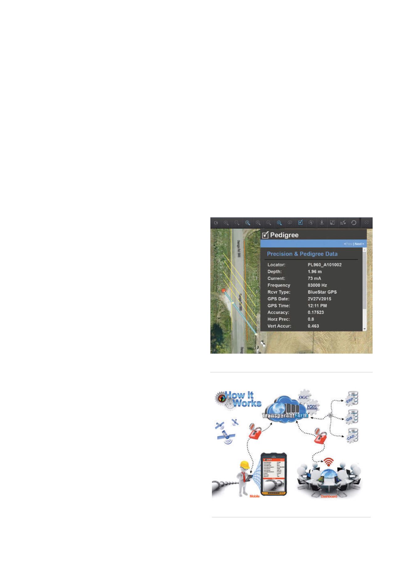
Figure 3.
Several of the many metadata fields with attributing
of Pedigree and Precision.
Figure 4.
How ProStar integrates processes and technologies.
JULY 2015
/
World Pipelines
77


